
Make a donation
Lashorst topographic map
Click on the map to display elevation.
Make a donation
About this map
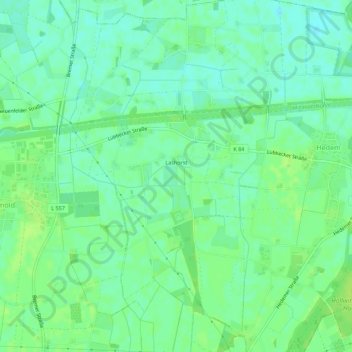
Name: Lashorst topographic map, elevation, terrain.
Average elevation: 51 m
Minimum elevation: 44 m
Maximum elevation: 57 m
Make a donation
Other topographic maps
Click on a map to view its topography, its elevation and its terrain.
Eininghausen
Deutschland > Nordrhein-Westfalen > Kreis Minden-Lübbecke > Preußisch Oldendorf
Average elevation: 152 m
Getmold
Deutschland > Nordrhein-Westfalen > Kreis Minden-Lübbecke > Preußisch Oldendorf
Average elevation: 52 m
Börninghausen
Deutschland > Nordrhein-Westfalen > Kreis Minden-Lübbecke > Preußisch Oldendorf
Aufgrund der im Altkreis Lübbecke einzigartigen topografischen Lage, spielt der Tourismus eine überdurchschnittliche Rolle.
Average elevation: 135 m
Fiegenburg
Deutschland > Nordrhein-Westfalen > Kreis Minden-Lübbecke > Preußisch Oldendorf > Fiegenburg
Average elevation: 121 m
Make a donation