
Make a donation
Marble Canyon topographic map
Click on the map to display elevation.
Make a donation
About this map
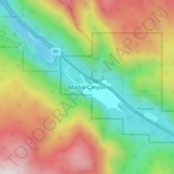
Name: Marble Canyon topographic map, elevation, terrain.
Location: Marble Canyon, British Columbia, Canada (50.80169 -121.69281 50.84169 -121.65281)
Average elevation: 1,221 m
Minimum elevation: 799 m
Maximum elevation: 1,824 m
Make a donation
Other topographic maps
Click on a map to view its topography, its elevation and its terrain.
Houston
Canada > British Columbia > Regional District of Bulkley-Nechako
The Houston Hikers' Society provides website where trail information, maps, photos and driving directions can be accessed. The Morice Mountain Nordic Ski Club is a volunteer non-profit society. The MMNSC is responsible for all developments and trail grooming as well as maintenance of the facilities, and for…
Average elevation: 728 m
Juan de Fuca Electoral Area
Canada > British Columbia > Capital Regional District
Average elevation: 255 m
Penticton
Canada > British Columbia > Regional District of Okanagan-Similkameen
Penticton is located at the geographical coordinates of 49°29′28″N 119°35′19″W / 49.49111°N 119.58861°W / 49.49111; -119.58861 (Penticton) and covers an area of 42.10 km2 (16.25 sq mi), with a maximum north–south distance of 7 km (4.3 mi) wide between the Okanagan Lake to the north…
Average elevation: 702 m
Garibaldi Provincial Park
Canada > British Columbia > Squamish-Lillooet Regional District
There are over 150 glaciers in the park, including the Garibaldi Névé and Mamquam icefields. The highest peak in Garibaldi Park is Wedge Mountain, at an elevation of 2,891 metres (9,485 ft). It also includes volcanic features such as an andesite tuya known as The Table, a cinder cone known as the Opal Cone,…
Average elevation: 1,318 m
Make a donation
Cortes Island
Canada > British Columbia > Strathcona Regional District > Area C (Cortes Island)
Average elevation: 72 m
Wasa Lake
Canada > British Columbia > Regional District of East Kootenay > Area E (Saint Mary/Skookumchuck) > Wasa
Average elevation: 793 m
Make a donation
Scotch Creek
Canada > British Columbia > Columbia-Shuswap Regional District > Area F (Scotch Creek/Seymour Arm)
Average elevation: 1,125 m
Adams Lake
Canada > British Columbia > Thompson-Nicola Regional District > Area O (Lower North Thompson)
According to one account, the lake is 63 kilometres (39 mi) long and 1.6 to 3.2 kilometres (1.0 to 2.0 mi) wide. The surface elevation is 404 metres (1,325 ft) above sea level. The mean depth of 299 metres (981 ft) and maximum depth of 457 metres (1,499 ft) make the second deepest lake in BC (next to Quesnel…
Average elevation: 1,177 m
Lillooet Lake
Canada > British Columbia > Squamish-Lillooet Regional District > Area C (Pemberton Valley/Mount Currie/D'Arcy)
Average elevation: 1,177 m
Radium Hot Springs
Canada > British Columbia > Regional District of East Kootenay
Average elevation: 912 m
Make a donation
Lake O'Hara
Canada > British Columbia > Columbia-Shuswap Regional District > Area A (Kicking Horse/Kinbasket Lake)
Lake O'Hara is a lake at an elevation of 2,020 metres (6,630 ft) in the alpine area of Yoho National Park, in the province of British Columbia, on the western side of the Great Divide with the province of Alberta and Banff National Park to the east. The lake and the valley are accessible through a bus service…
Average elevation: 2,276 m
Area A (Kicking Horse/Kinbasket Lake)
Canada > British Columbia > Columbia-Shuswap Regional District
Average elevation: 1,846 m
Fairview
Canada > British Columbia > Metro Vancouver Regional District > Vancouver
Average elevation: 31 m
Harrison Lake
Canada > British Columbia > Fraser Valley Regional District > Area C (Sasquatch Country)
Average elevation: 815 m
Make a donation
Navvy Jack Point Park
Canada > British Columbia > Metro Vancouver Regional District > West Vancouver
Average elevation: 23 m
Make a donation
Mikes Island
Canada > British Columbia > Alberni-Clayoquot Regional District > Area C (Long Beach)
Average elevation: 6 m
Area B (Lazo North)
Canada > British Columbia > Comox Valley Regional District
Average elevation: 11 m