
Freiburg topographic map
Interactive map
Click on the map to display elevation.
About this map
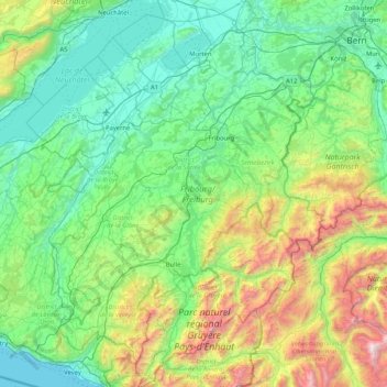
Name: Freiburg topographic map, elevation, terrain.
Location: Freiburg, Schweiz (46.43791 6.74231 47.00680 7.38027)
Average elevation: 894 m
Minimum elevation: 368 m
Maximum elevation: 2,735 m
Other topographic maps
Click on a map to view its topography, its elevation and its terrain.
Sankt Silvester
Schweiz > Freiburg > Sensebezirk
Sankt Silvester, Sensebezirk, Freiburg, 1736, Schweiz
Average elevation: 876 m
Vuissens
Schweiz > Freiburg > Broye Bezirk > Estavayer
Vuissens, Estavayer, Broye Bezirk, Freiburg, 1486, Schweiz
Average elevation: 745 m
Botterens
Schweiz > Freiburg > Greyerzbezirk
Botterens, Greyerzbezirk, Freiburg, 1652, Schweiz
Average elevation: 832 m
Düdingen
Schweiz > Freiburg > Sensebezirk
Düdingen, Sensebezirk, Freiburg, 3186, Schweiz
Average elevation: 618 m
Vallon
Schweiz > Freiburg > Broye Bezirk
Vallon, Broye Bezirk, Freiburg, 1565, Schweiz
Average elevation: 474 m
Freiburg
Schweiz > Freiburg > District de la Sarine
Freiburg, District de la Sarine, Freiburg, Schweiz
Average elevation: 638 m
Staatswald Galm
Schweiz > Freiburg > Seebezirk
Staatswald Galm, Seebezirk, Freiburg, Schweiz
Average elevation: 565 m
Schmitten
Schweiz > Freiburg > Sensebezirk
Schmitten, Sensebezirk, Freiburg, 3185, Schweiz
Average elevation: 659 m
Wüppingen
Schweiz > Freiburg > Greyerzbezirk
Wüppingen, Marsing, Greyerzbezirk, Freiburg, 1633, Schweiz
Average elevation: 744 m
Grossried
Schweiz > Freiburg > Sensebezirk > Niedermettlen
Grossried, Niedermettlen, Ueberstorf, Sensebezirk, Freiburg, 3182, Schweiz
Average elevation: 626 m
Cheyres
Schweiz > Freiburg > Broye Bezirk > Cheyres-Châbles
Cheyres, Cheyres-Châbles, Broye Bezirk, Freiburg, 1468, Schweiz
Average elevation: 514 m
Gumschen
Schweiz > Freiburg > District de la Sarine
Gumschen, District de la Sarine, Freiburg, Schweiz
Average elevation: 626 m
Heitenried
Schweiz > Freiburg > Sensebezirk > Heitenried
Heitenried, Sensebezirk, Freiburg, 1714, Schweiz
Average elevation: 727 m
Le Moléson
Schweiz > Freiburg > Greyerzbezirk > Gruyères
Le Moléson, Gruyères, Greyerzbezirk, Freiburg, 1663, Schweiz
Average elevation: 1,503 m
Schwarzsee
Schweiz > Freiburg > Sensebezirk > Schwarzsee
Schwarzsee, Lenggera, Schwarzsee, Plaffeien, Sensebezirk, Freiburg, 1716, Schweiz
Average elevation: 1,229 m
Schafberg
Schweiz > Freiburg > Sensebezirk > Plaffeien
Schafberg, Plaffeien, Sensebezirk, Freiburg, 1716, Schweiz
Average elevation: 1,815 m
Rechthalten
Schweiz > Freiburg > Rechthalten
Rechthalten, Sensebezirk, Freiburg, 1718, Schweiz
Average elevation: 854 m
La Sarine
Schweiz > Freiburg > Bas-Intyamon
La Sarine, Bas-Intyamon, Greyerzbezirk, Freiburg, 1666, Schweiz
Average elevation: 897 m
Jaun
Schweiz > Freiburg > Greyerzbezirk
Jaun, Greyerzbezirk, Freiburg, 1656, Schweiz
Average elevation: 1,487 m