
Make a donation
Blue Nile topographic map
Click on the map to display elevation.
Make a donation
About this map
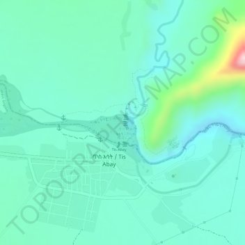
Name: Blue Nile topographic map, elevation, terrain.
Location: Blue Nile, South Gonder, Amhara Region, Ethiopia (11.48973 37.58601 11.49075 37.58859)
Average elevation: 1,649 m
Minimum elevation: 1,590 m
Maximum elevation: 1,858 m
Make a donation
Other topographic maps
Click on a map to view its topography, its elevation and its terrain.
Debre Markos
Ethiopia > Amhara Region > Guzamn
Debre Markos is located 300 km north-west of Addis Ababa along the Addis Ababa-Gondar road at an elevation of over 2400 meters.
Average elevation: 2,343 m
Injibara
Injibara (Amharic: እንጅባራ) is a town in Ethiopia. It is the administrative center of the Agew Awi Zone in the Amhara Region. Injibara is located at 10°57′N 36°56′E / 10.950°N 36.933°E / 10.950; 36.933, in Banja Shekudad woreda at an elevation of 2,560 meters (8,400 ft) above sea level.
Average elevation: 2,575 m