
Make a donation
Japan topographic map
Click on the map to display elevation.
Make a donation
Japan
Japan's topography is dominated by rugged, mountainous terrain, with over four-fifths of its landmass consisting of mountains. The country's volcanic origins contribute to the striking landscape, with towering peaks and active volcanoes, including the iconic Mount Fuji, which rises to 12,388 feet (3,776 meters). The Japanese Alps, which run through Honshu, feature some of the highest peaks in the country, often exceeding 9,800 feet (3,000 meters). Despite the challenging mountainous environment, fertile valleys and coastal plains offer opportunities for agriculture, particularly in low-lying areas along the Pacific coast. The intricate coastline, shaped by steep cliffs, bays, and sandy beaches, further enhances the country's scenic beauty
Make a donation
About this map
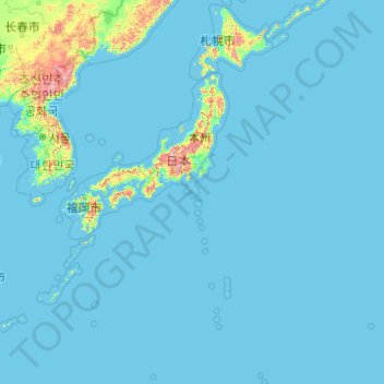
Name: Japan topographic map, elevation, terrain.
Location: Japan (20.21458 122.71418 45.71120 154.20554)
Average elevation: 58 m
Minimum elevation: -2 m
Maximum elevation: 2,683 m
Make a donation
Other topographic maps
Click on a map to view its topography, its elevation and its terrain.
Aramoun
Lebanon > Mount Lebanon Governorate
Aramoun (Arabic: عرمون) is a village in the Aley District of Mount Lebanon, Lebanon, lying to the east of Khalde and 22 kilometres away from Beirut. Aramoun's altitude ranges between 250 meters to 600 meters further east. The village has a Druze and Christian community, major families are Yehia, Jawhari,…
Average elevation: 467 m
Corró d'Amunt
Spain > Catalonia > Vallès Oriental > les Franqueses del Vallès
Average elevation: 287 m
Make a donation
Pièce du Moulin
France > Nouvelle-Aquitaine > Charente-Maritime > Le Grand-Village-Plage
Average elevation: 4 m
Make a donation
Addis Ababa
Ethiopia > Addis Ababa > Arada
Addis Ababa (/ˌædɪs ˈæbəbə/ AD-iss AB-ə-bə; Amharic: አዲስ አበባ [adˈdis ˈaβəβa] , lit. 'new flower'; Oromo: Finfinnee, lit. 'fountain of hot mineral water') is the capital city of Ethiopia. With an estimated population of 2,739,551 inhabitants as of the 2007 census, it is the largest…
Average elevation: 2,517 m
Make a donation
Make a donation
Make a donation
Make a donation
Make a donation
Sungai Haji Dorani
Malaysia > Selangor > Kampung Sungai Haji Dorani > Kampung Nelayan Sungai Haji Durani
Average elevation: 3 m
Make a donation
Make a donation
Bayang
The topography of the municipality is generally characterized by moderately sloping lands. Approximately 2,606 hectares (63.45%) have moderate slopes of 8 – 15%. Steep lands with a slope 40 – 60% comprise 20.14% (827) ha. About 674 (16.41) have nearly level terrain.
Average elevation: 782 m
San Jose
The municipality is in a valley bounded on the east by the Palusong Mountain Range moving south and on the west by the Hitaasan Mountain Range. The land is generally alluvial flat and swamplands which has an elevation of less than 10 metres (33 ft) above sea level, while going south, south easterly, the…
Average elevation: 15 m
Make a donation
Make a donation
Make a donation
Make a donation
Make a donation
Johannesburg
South Africa > Gauteng > City of Johannesburg Metropolitan Municipality
Johannesburg is located in the eastern plateau area of South Africa known as the Highveld, at an elevation of 1,753 metres (5,751 ft). The former Central Business District is located on the southern side of the prominent ridge called the Witwatersrand (English: White Water's Ridge) and the terrain falls to the…
Average elevation: 1,615 m
Make a donation
Lindridge Park
United Kingdom > England > Devon > Teignbridge > Luton > Humber
Average elevation: 125 m
Sudeley Castle
United Kingdom > England > Gloucestershire > Cheltenham > Sudeley
His elevation almost certainly came from his assistance in the suppression of the Wyatt rebellion.
Average elevation: 135 m
Make a donation
Αβία
Greece > Peloponnese Region > Messenia Regional Unit > Municipal Unit of Avia
Average elevation: 45 m
Make a donation
Worsbrough
United Kingdom > England > Barnsley
On High Street, Worsbrough Dale. The east elevation bears the inscriptions "AD 1903" and "Ebenezer Wesleyan Reform". There are also foundation stones either side of the doorway inscribed with "EBENEZER CHAPEL 1854". This suggests that the chapel was built in 1854 and extended upwards in 1903.
Average elevation: 98 m
Make a donation
Kampos Marathokampou
Greece > Northern Aegean > Samos Regional Unit > Municipal Unit of Marathokabos
Average elevation: 99 m
Make a donation
Le Plan de l'Envers
France > Auvergne-Rhône-Alpes > Upper Savoy > Vallorcine
Average elevation: 1,721 m
Make a donation
Make a donation
Make a donation
Vikos–Aoos National Park
Greece > Epirus > Ioannina Regional Unit
The Vikos–Aoös National Park (Greek: Εθνικός Δρυμός Βίκου–Αώου, romanized: Ethnikós Drymós Víkou–Aóou) is a national park in the region of Epirus in northwestern Greece. The park, founded in 1973, is one of ten national parks in mainland Greece and is located 30 kilometres (19…
Average elevation: 1,147 m
Make a donation
Make a donation
Bansko
Bansko lies at the foot of the Pirin Mountains, not far from the national park of the same name, in the valley of the Nestos River at an elevation of 925 meters above sea level. It is a ski resort. The city is about 160 km from Sofia and about 220 km from Thessaloniki.
Average elevation: 1,034 m
Eskisehir
Eskişehir has a cold semi-arid climate (BSk) under the Köppen climate classification, and a temperate continental climate (Dc) under the Trewartha climate classification. The city features cold, snowy winters and warm, dry summers. Rainfall occurs mostly during the spring and autumn. Due to Eskişehir's high…
Average elevation: 949 m
Make a donation