
Ellef Ringnes Island topographic map
Interactive map
Click on the map to display elevation.
About this map
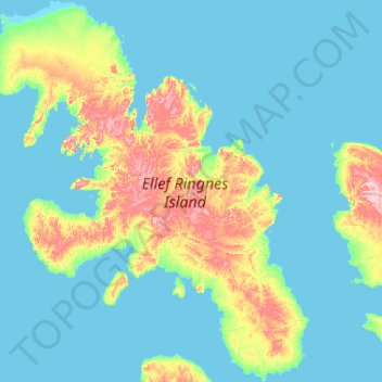
Name: Ellef Ringnes Island topographic map, elevation, terrain.
Location: Ellef Ringnes Island, Nunavut, Kanada (77.78425 -105.64883 79.39106 -98.91250)
Average elevation: 25 m
Minimum elevation: -1 m
Maximum elevation: 299 m
Other topographic maps
Click on a map to view its topography, its elevation and its terrain.