
Make a donation
Bozkurt topographic map
Click on the map to display elevation.
Make a donation
Bozkurt
Bozkurt is a town in the Kastamonu Province in the Black Sea region of Turkey. It is the seat of Bozkurt District. Its population is 5,329 (2021). The town lies at an elevation of 252 m (827 ft).
Make a donation
About this map
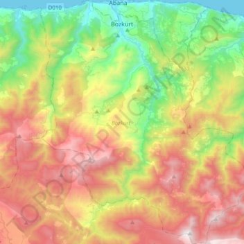
Name: Bozkurt topographic map, elevation, terrain.
Location: Bozkurt, Kastamonu, Black Sea Region, 37680, Turkey (41.75644 33.91130 41.98081 34.17051)
Average elevation: 851 m
Minimum elevation: 0 m
Maximum elevation: 2,002 m
Make a donation
Other topographic maps
Click on a map to view its topography, its elevation and its terrain.
Make a donation
Pontic Mountains
Winter conditions are very harsh, and snow even in summer months isn't unusual above certain elevations.
Average elevation: 2,800 m
Make a donation
Make a donation
Make a donation
Make a donation
Make a donation
Make a donation
Make a donation
Make a donation
Make a donation
Make a donation
Make a donation
Make a donation
Make a donation
Make a donation
Make a donation
Mount Erciyes
The climate of the region is influenced by topography, with the Taurus and Kaçkar Mountains blocking the entry of moisture into Anatolia. Summers are dry and hot and winters wet and cold; in Kayseri, summer temperatures are about 19 °C (66 °F) and winter temperature about 0 °C (32 °F). Precipitation at…
Average elevation: 3,329 m
Make a donation
Make a donation
Keban Dam
The Keban Dam is a combined rockfill and concrete gravity hydroelectric dam operated by the State Hydraulic Works (DSİ). The dam is 1,097 metres (3,599 ft) long and its crest is 207 metres (679 ft) above the level of the river-bed (848 metres (2,782 ft) above sea-level). Its eight water turbines are capable…
Average elevation: 844 m
Make a donation
Make a donation
Make a donation
Make a donation
Make a donation
Make a donation
Make a donation