
Make a donation
Kiln topographic map
Click on the map to display elevation.
Make a donation
About this map
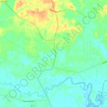
Name: Kiln topographic map, elevation, terrain.
Location: Kiln, Hancock County, Mississippi, United States (30.38497 -89.47797 30.45286 -89.38247)
Average elevation: 11 m
Minimum elevation: -4 m
Maximum elevation: 35 m
Make a donation
Other topographic maps
Click on a map to view its topography, its elevation and its terrain.
Meridian
United States > Mississippi > Lauderdale County
Meridian is located in the East Central Hills region of Mississippi in Lauderdale County. According to the United States Census Bureau, the city has a total area of 54.50 square miles (141.2 km2), of which 53.74 square miles (139.2 km2) are land and 0.76 square miles (2.0 km2), or 1.40%, are water. Along major…
Average elevation: 118 m
Make a donation
Make a donation
Make a donation
Make a donation
Make a donation
Make a donation
Make a donation
Make a donation
Make a donation
Make a donation
Make a donation
Make a donation
Make a donation
Make a donation
Make a donation
Make a donation
Make a donation
Make a donation
Oxford
United States > Mississippi > Lafayette County
The city is located in the North Central Hills region of Mississippi. The region is known for its heavily forested hills made up of red clay. The area is higher and greater in relief than areas to the west (such as the Mississippi Delta or loess bluffs along the Delta), but lower in elevation than areas in…
Average elevation: 132 m
Make a donation
Make a donation
Make a donation
Bay St. Louis
United States > Mississippi > Hancock County
USGS topographic maps show a common 25-foot (7.6 m) elevation contour line running throughout a ridge along the former routing of Highway 90 (Old Spanish Trail) on the western edge of the city. As higher ground, this area was spared inundation from the storm surge of Hurricane Katrina.
Average elevation: 2 m
Make a donation
Make a donation
Make a donation
Make a donation