
District de Pengjiang topographic map
Interactive map
Click on the map to display elevation.
About this map
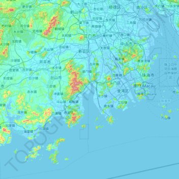
Name: District de Pengjiang topographic map, elevation, terrain.
Location: District de Pengjiang, Jiangmen, Guangdong, Chine (21.45043 111.99921 22.85802 113.25747)
Average elevation: 30 m
Minimum elevation: -7 m
Maximum elevation: 916 m
Other topographic maps
Click on a map to view its topography, its elevation and its terrain.