
Taishan topographic map
Interactive map
Click on the map to display elevation.
About this map
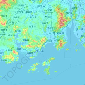
Name: Taishan topographic map, elevation, terrain.
Location: Taishan, Jiangmen, Guangdong, Chine (21.45043 112.29900 22.44738 113.06511)
Average elevation: 42 m
Minimum elevation: -11 m
Maximum elevation: 937 m
Other topographic maps
Click on a map to view its topography, its elevation and its terrain.
District de Pengjiang
District de Pengjiang, Jiangmen, Guangdong, Chine
Average elevation: 30 m