
Thank you for supporting this site ❤️
Make a donation
Make a donation
Polvoranca topographic map
Click on the map to display elevation.
Thank you for supporting this site ❤️
Make a donation
Make a donation
About this map
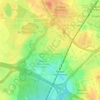
Name: Polvoranca topographic map, elevation, terrain.
Location: Polvoranca, Leganés, Comunidad de Madrid, España (40.30720 -3.80012 40.32618 -3.77506)
Average elevation: 674 m
Minimum elevation: 649 m
Maximum elevation: 693 m
Thank you for supporting this site ❤️
Make a donation
Make a donation
Other topographic maps
Click on a map to view its topography, its elevation and its terrain.