
District of Prishtina topographic map
Interactive map
Click on the map to display elevation.
About this map
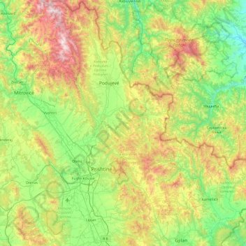
Name: District of Prishtina topographic map, elevation, terrain.
Location: District of Prishtina, Kosovo (42.44506 20.76076 43.13834 21.55281)
Average elevation: 722 m
Minimum elevation: 257 m
Maximum elevation: 1,763 m
Other topographic maps
Click on a map to view its topography, its elevation and its terrain.
Vrellë e Goleshit
Vrellë e Goleshit, Municipality of Lipjan / Lipljan, Kosovo
Average elevation: 643 m
Municipality of Lipjan / Lipljan
Municipality of Lipjan / Lipljan, Kosovo
Average elevation: 662 m