
Thank you for supporting this site ❤️
Make a donation
Make a donation
Giza topographic map
Click on the map to display elevation.
Thank you for supporting this site ❤️
Make a donation
Make a donation
About this map
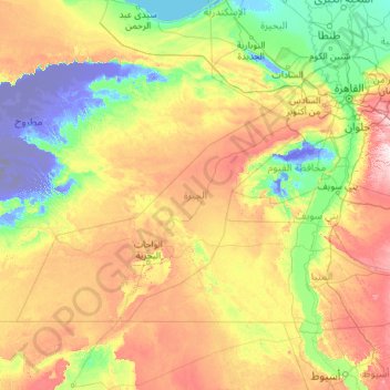
Name: Giza topographic map, elevation, terrain.
Location: Giza, Egypt (27.73800 27.31059 30.34013 31.90628)
Average elevation: 134 m
Minimum elevation: -103 m
Maximum elevation: 661 m
Thank you for supporting this site ❤️
Make a donation
Make a donation
Other topographic maps
Click on a map to view its topography, its elevation and its terrain.
Sabkha of El Qattara Depression
Egypt > Matrouh Governorate > Sabkha of El Qattara Depression
Average elevation: 43 m
Thank you for supporting this site ❤️
Make a donation
Make a donation
Thank you for supporting this site ❤️
Make a donation
Make a donation
Thank you for supporting this site ❤️
Make a donation
Make a donation