
Thank you for supporting this site ❤️
Make a donation
Make a donation
Red Sea Governorate topographic map
Click on the map to display elevation.
Thank you for supporting this site ❤️
Make a donation
Make a donation
About this map
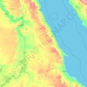
Name: Red Sea Governorate topographic map, elevation, terrain.
Location: Red Sea Governorate, Egypt (22.06018 31.53999 27.26018 36.73999)
Average elevation: 239 m
Minimum elevation: -1 m
Maximum elevation: 1,901 m
Thank you for supporting this site ❤️
Make a donation
Make a donation
Other topographic maps
Click on a map to view its topography, its elevation and its terrain.
Sabkha of El Qattara Depression
Egypt > Matrouh Governorate > Sabkha of El Qattara Depression
Average elevation: 43 m
Thank you for supporting this site ❤️
Make a donation
Make a donation
Thank you for supporting this site ❤️
Make a donation
Make a donation