
Thank you for supporting this site ❤️
Make a donation
Make a donation
Luxor topographic map
Click on the map to display elevation.
Thank you for supporting this site ❤️
Make a donation
Make a donation
About this map
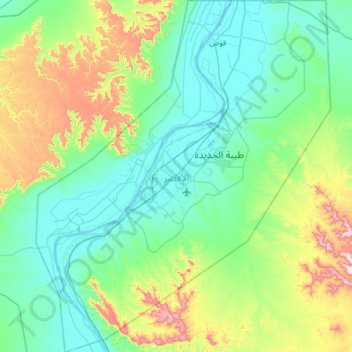
Name: Luxor topographic map, elevation, terrain.
Location: Luxor, Egypt (25.40839 32.43213 25.98460 32.96795)
Average elevation: 218 m
Minimum elevation: 66 m
Maximum elevation: 784 m
Thank you for supporting this site ❤️
Make a donation
Make a donation
Other topographic maps
Click on a map to view its topography, its elevation and its terrain.
Sabkha of El Qattara Depression
Egypt > Matrouh Governorate > Sabkha of El Qattara Depression
Average elevation: 43 m
Thank you for supporting this site ❤️
Make a donation
Make a donation
Thank you for supporting this site ❤️
Make a donation
Make a donation
Thank you for supporting this site ❤️
Make a donation
Make a donation