
Salcedo topographic map
Interactive map
Click on the map to display elevation.
About this map
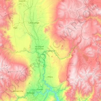
Name: Salcedo topographic map, elevation, terrain.
Location: Salcedo, Cotopaxi, Ecuador (-1.15480 -78.84493 -0.95920 -78.40152)
Average elevation: 3,359 m
Minimum elevation: 2,133 m
Maximum elevation: 4,299 m
Other topographic maps
Click on a map to view its topography, its elevation and its terrain.
Laguna Quilotoa
Ecuador > Cotopaxi > Sigchos > Chugchillan
Laguna Quilotoa, Chugchillan, Sigchos, Cotopaxi, Ecuador
Average elevation: 3,636 m
San Juan de Pastocalle
Ecuador > Cotopaxi > Latacunga
San Juan de Pastocalle, Latacunga, Cotopaxi, Ecuador
Average elevation: 3,465 m
Belisario Quevedo
Ecuador > Cotopaxi > Latacunga
Belisario Quevedo, Latacunga, Cotopaxi, Ecuador
Average elevation: 2,945 m
Pastocalle
Ecuador > Cotopaxi > Latacunga > Latacunga
Pastocalle, Latacunga, Cotopaxi, 050108, Ecuador
Average elevation: 2,851 m
El Salvario
Ecuador > Cotopaxi > Latacunga > Latacunga > El Salvario
El Salvario, Latacunga, Cotopaxi, 050108, Ecuador
Average elevation: 2,818 m