
Pujilí topographic map
Interactive map
Click on the map to display elevation.
About this map
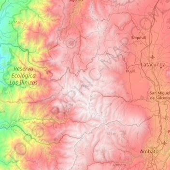
Name: Pujilí topographic map, elevation, terrain.
Location: Pujilí, Cotopaxi, Ecuador (-1.19723 -79.21367 -0.81773 -78.61200)
Average elevation: 2,940 m
Minimum elevation: 359 m
Maximum elevation: 4,534 m
Other topographic maps
Click on a map to view its topography, its elevation and its terrain.
Laguna Quilotoa
Ecuador > Cotopaxi > Sigchos > Chugchillan
Laguna Quilotoa, Chugchillan, Sigchos, Cotopaxi, Ecuador
Average elevation: 3,636 m
San Juan de Pastocalle
Ecuador > Cotopaxi > Latacunga
San Juan de Pastocalle, Latacunga, Cotopaxi, Ecuador
Average elevation: 3,465 m
Belisario Quevedo
Ecuador > Cotopaxi > Latacunga
Belisario Quevedo, Latacunga, Cotopaxi, Ecuador
Average elevation: 2,945 m
Pastocalle
Ecuador > Cotopaxi > Latacunga > Latacunga
Pastocalle, Latacunga, Cotopaxi, 050108, Ecuador
Average elevation: 2,851 m
El Salvario
Ecuador > Cotopaxi > Latacunga > Latacunga > El Salvario
El Salvario, Latacunga, Cotopaxi, 050108, Ecuador
Average elevation: 2,818 m