
Make a donation
Chaillol 1600 topographic map
Click on the map to display elevation.
Make a donation
About this map
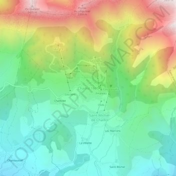
Name: Chaillol 1600 topographic map, elevation, terrain.
Average elevation: 1,665 m
Minimum elevation: 1,225 m
Maximum elevation: 2,470 m
Make a donation
Other topographic maps
Click on a map to view its topography, its elevation and its terrain.
Gap
France > Provence-Alpes-Côte d'Azur > Hautes-Alpes
The cover of morainic debris is omnipresent in the Sillon de Gap but is not the only vestige of the Quaternary glaciation. There is also the typical topography of glacial valleys. The location of the town of Gap corresponds to an Ombilic glaciaire, where large quantities of clay were deposited. Upstream lies…
Average elevation: 1,146 m
Vallouise
France > Provence-Alpes-Côte d'Azur > Hautes-Alpes > Vallouise-Pelvoux
Average elevation: 2,378 m
Pelvoux
France > Provence-Alpes-Côte d'Azur > Hautes-Alpes > Vallouise-Pelvoux
Average elevation: 2,459 m
Make a donation
Risoul
France > Provence-Alpes-Côte d'Azur > Hautes-Alpes
The resort has 55 ski lifts, including a cable car and 14 chairs. These give it an uplift capacity of 57,000 skiers per hour. The resort is linked to Vars through the Forêt Blanche ski area giving a total of 180 km (110 mi) of ski runs situated between 1650 and 2750 metres altitude.
Average elevation: 1,764 m
Make a donation
Saint-Bonnet-en-Champsaur
France > Provence-Alpes-Côte d'Azur > Hautes-Alpes
Average elevation: 1,216 m
Make a donation
Saint-Eusèbe-en-Champsaur
France > Provence-Alpes-Côte d'Azur > Hautes-Alpes > Aubessagne
Average elevation: 1,029 m
Make a donation
Make a donation