
Make a donation
Gap topographic map
Click on the map to display elevation.
Make a donation
Gap
The cover of morainic debris is omnipresent in the Sillon de Gap but is not the only vestige of the Quaternary glaciation. There is also the typical topography of glacial valleys. The location of the town of Gap corresponds to an Ombilic glaciaire, where large quantities of clay were deposited. Upstream lies the Verrou glaciaire [fr] [glacial lock] of Pont-Sarrazin and downstream of Tourronde.
Make a donation
About this map
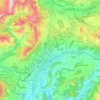
Name: Gap topographic map, elevation, terrain.
Average elevation: 1,146 m
Minimum elevation: 629 m
Maximum elevation: 2,374 m
Make a donation
Other topographic maps
Click on a map to view its topography, its elevation and its terrain.
Serre Chevalier
France > Provence-Alpes-Côte d'Azur > Hautes-Alpes > Puy-Saint-André
The maximum elevation for skiing is at Telesiege Yret at 2,800 m (9,190 ft) above sea level, and the minimum is 1,200 m (3,940 ft), a total vertical drop of 1,600 m (5,250 ft). One of the outstanding features of Serre Chevalier is the wooded nature of the slopes. The timber line is at 2,150 m (7,050 ft),…
Average elevation: 2,256 m
Col du Lautaret
France > Provence-Alpes-Côte d'Azur > Hautes-Alpes > Le Monêtier-les-Bains
From the west, the climb starts at Les Clapier, near Le Bourg-d'Oisans, from where the climb is 34.2 km (21.3 mi) long, gaining 1,312 m (4,304 ft) in altitude, at an average gradient of 3.8%, with the steepest section being at 7.5% in the first kilometre.
Average elevation: 2,261 m
Lucis
France > Provence-Alpes-Côte d'Azur > Hautes-Alpes > Villar-Saint-Pancrace
Average elevation: 1,326 m
Le Villardon
France > Provence-Alpes-Côte d'Azur > Hautes-Alpes > Aubessagne
Average elevation: 1,063 m
Make a donation
Orcières-Merlette
France > Provence-Alpes-Côte d'Azur > Hautes-Alpes > Orcières
Average elevation: 1,874 m
Plan de la Loubiere
France > Provence-Alpes-Côte d'Azur > Hautes-Alpes > La Roche-de-Rame
Average elevation: 2,056 m
Le Moulin
France > Provence-Alpes-Côte d'Azur > Hautes-Alpes > Saint-Firmin
Average elevation: 1,119 m
Les Chaussendents
France > Provence-Alpes-Côte d'Azur > Hautes-Alpes > La Chapelle-en-Valgaudémar
Average elevation: 1,619 m
Make a donation
La Rua
France > Provence-Alpes-Côte d'Azur > Hautes-Alpes > Molines-en-Queyras
Average elevation: 1,982 m
Make a donation
Station de Ski de Réallon
France > Provence-Alpes-Côte d'Azur > Hautes-Alpes > Réallon
Average elevation: 1,494 m
Les Allouviers
France > Provence-Alpes-Côte d'Azur > Hautes-Alpes > Gap > Romette
Average elevation: 957 m
Les Payas
France > Provence-Alpes-Côte d'Azur > Hautes-Alpes > Saint-Bonnet-en-Champsaur
Average elevation: 1,325 m
Make a donation
Le Château d'Ancelle
France > Provence-Alpes-Côte d'Azur > Hautes-Alpes > Ancelle
Average elevation: 1,407 m
Les Forests
France > Provence-Alpes-Côte d'Azur > Hautes-Alpes > Saint-Léger-les-Mélèzes
Average elevation: 1,383 m