
Thank you for supporting this site ❤️
Make a donation
Make a donation
Bispingen topographic map
Click on the map to display elevation.
Thank you for supporting this site ❤️
Make a donation
Make a donation
About this map
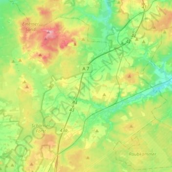
Name: Bispingen topographic map, elevation, terrain.
Location: Bispingen, Heidekreis, Lower Saxony, 29646, Germany (53.05650 9.86038 53.18087 10.11791)
Average elevation: 91 m
Minimum elevation: 48 m
Maximum elevation: 168 m
Thank you for supporting this site ❤️
Make a donation
Make a donation
Other topographic maps
Click on a map to view its topography, its elevation and its terrain.
Lüneburg Heath
Germany > Lower Saxony > Heidekreis > Soltau > Hötzingen > Emhof
Average elevation: 85 m
Thank you for supporting this site ❤️
Make a donation
Make a donation