
Hohensolms topographic map
Interactive map
Click on the map to display elevation.
About this map
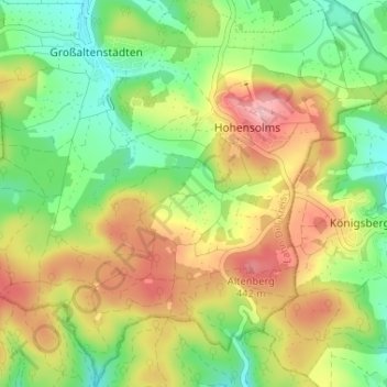
Name: Hohensolms topographic map, elevation, terrain.
Location: Hohensolms, Hohenahr, Lahn-Dill-Kreis, Hessen, Deutschland (50.62440 8.48590 50.66561 8.53860)
Average elevation: 354 m
Minimum elevation: 285 m
Maximum elevation: 440 m
Other topographic maps
Click on a map to view its topography, its elevation and its terrain.
Erda
Deutschland > Hessen > Lahn-Dill-Kreis > Hohenahr
Erda, Hohenahr, Lahn-Dill-Kreis, Hessen, 35644, Deutschland
Average elevation: 320 m
Altenberg
Deutschland > Hessen > Lahn-Dill-Kreis > Hohenahr
Altenberg, Hohenahr, Lahn-Dill-Kreis, Hessen, 35585, Deutschland
Average elevation: 366 m
Altenkirchen
Deutschland > Hessen > Lahn-Dill-Kreis > Hohenahr
Altenkirchen, Hohenahr, Lahn-Dill-Kreis, Hessen, Deutschland
Average elevation: 324 m