
Cerro Lobo topographic map
Interactive map
Click on the map to display elevation.
About this map
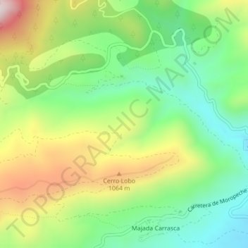
Name: Cerro Lobo topographic map, elevation, terrain.
Location: Cerro Lobo, Yeste, Albacete, Castilla-La Mancha, España (38.41084 -2.36099 38.43084 -2.34099)
Average elevation: 888 m
Minimum elevation: 661 m
Maximum elevation: 1,236 m
Other topographic maps
Click on a map to view its topography, its elevation and its terrain.
Parque Natural de los Calares del Mundo y de la Sima
España > Castilla-La Mancha > Yeste
Parque Natural de los Calares del Mundo y de la Sima, AB-512, Los Ruscas, Tús, Yeste, Albacete, Castilla-La Mancha, 02485, España
Average elevation: 1,125 m
Graya
España > Castilla-La Mancha > Yeste > Graya
Graya, Yeste, Albacete, Castilla-La Mancha, España
Average elevation: 932 m
Los Argüellos
España > Castilla-La Mancha > Yeste
Los Argüellos, Yeste, Albacete, Castilla-La Mancha, España
Average elevation: 671 m