
Mahendragiri topographic map
Interactive map
Click on the map to display elevation.
About this map
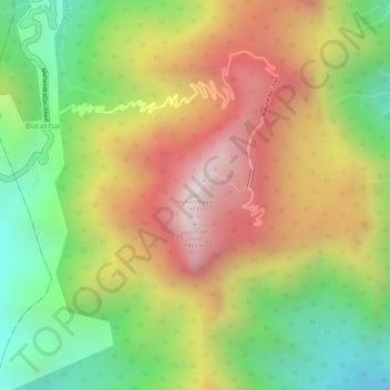
Name: Mahendragiri topographic map, elevation, terrain.
Average elevation: 1,108 m
Minimum elevation: 711 m
Maximum elevation: 1,494 m
Mahendragiri, is a mountain in Rayagada block of the district of Gajapati, Odisha, India. It is situated amongst the Eastern Ghats at an elevation of 1,501 metres (4,925 ft).It is second biodiversity Heritage Site of Odisha. This is considered as one out of Seven Kula Parvat of India.
Other topographic maps
Click on a map to view its topography, its elevation and its terrain.
Eastern Ghats
India > Odisha > Ramagiri > Burakhat
Eastern Ghats, Burakhat, Ramagiri, Gajapati District, Odisha, India
Average elevation: 1,130 m