
Make a donation
Lihuel Calel topographic map
Click on the map to display elevation.
Make a donation
About this map
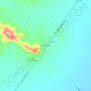
Name: Lihuel Calel topographic map, elevation, terrain.
Average elevation: 376 m
Minimum elevation: 334 m
Maximum elevation: 586 m
Make a donation
Other topographic maps
Click on a map to view its topography, its elevation and its terrain.
Santa Rosa
The town occupies part of a centripetal basin having their base in Don Tomás Lagoon, where rainwater drains from the surrounding area. The floor area lies west of it, in hilly terrain where the highest elevations are in the east, with two small plateaus located 200 meters. This high turnover is also observed…
Average elevation: 185 m
Make a donation