
Günzburg topographic map
Interactive map
Click on the map to display elevation.
About this map
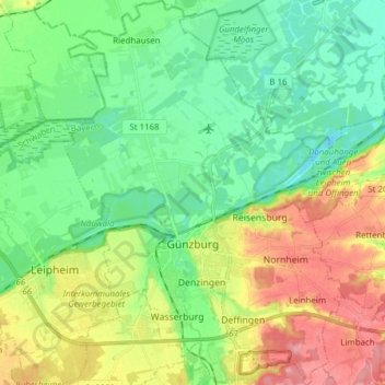
Name: Günzburg topographic map, elevation, terrain.
Location: Günzburg, Landkreis Günzburg, Bayern, 89312, Deutschland (48.41795 10.22520 48.52011 10.33729)
Average elevation: 461 m
Minimum elevation: 426 m
Maximum elevation: 525 m
Günzburg liegt an der Mündung der Günz und der Nau in die Donau auf einer Höhe von 440–517 Metern. Die Stadt ist Teil des Schwäbischen Barockwinkels und Ober- bzw. Mittelschwabens. Naturräumlich gehört sie zum Alpenvorland bzw. zur Donau-Iller-Lech-Platte; nördlich der Stadt beginnt das Donauried bzw. das Donaumoos.
Other topographic maps
Click on a map to view its topography, its elevation and its terrain.
Freihalden
Deutschland > Bayern > Landkreis Günzburg
Freihalden, Jettingen-Scheppach, Landkreis Günzburg, Bayern, 89343, Deutschland
Average elevation: 518 m