
Make a donation
Namangan Province topographic map
Click on the map to display elevation.
Make a donation
About this map
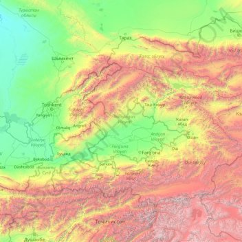
Name: Namangan Province topographic map, elevation, terrain.
Location: Namangan Province, Uzbekistan (38.40363 68.66120 43.60363 73.86120)
Average elevation: 1,859 m
Minimum elevation: 181 m
Maximum elevation: 7,004 m
Make a donation
Other topographic maps
Click on a map to view its topography, its elevation and its terrain.
Nukus
Uzbekistan > Republic of Karakalpakstan > Nókis qalası hákimiyatı
The most recent study was conducted in 1998 during the educational field archaeological practice of the Department of History of the NGPI named after Azhiniyaza. The topography of the settlement was studied, and an 18 m2 room was excavated in the early medieval part. A human burial was opened, and bones were…
Average elevation: 79 m
Bukhara
About 140 miles (230 km) west of Samarkand in south-central Uzbekistan, Bukhara is located on the Zeravshan River, at an elevation of 751 feet (229 meters).
Average elevation: 225 m
Make a donation
Make a donation
Make a donation
Make a donation
Jizzax
From the slopes of the mountains at an altitude of 1800 meters above sea level, pine forests begin. As the mountains rise, the pine forest thickens.
Average elevation: 381 m