
Pulau Siberut topographic map
Interactive map
Click on the map to display elevation.
About this map
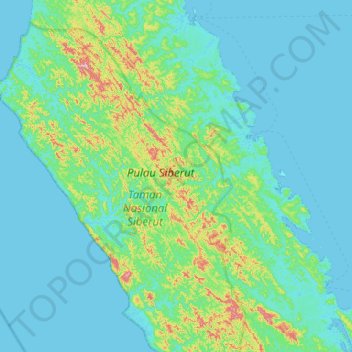
Name: Pulau Siberut topographic map, elevation, terrain.
Location: Pulau Siberut, Sumbar, Indonésie (-1.68535 98.60242 -1.04535 99.24242)
Average elevation: 45 m
Minimum elevation: -1 m
Maximum elevation: 356 m
Other topographic maps
Click on a map to view its topography, its elevation and its terrain.
Marapi
Indonésie > Sumbar > Bukittinggi
Marapi, Bukittinggi, Agam, Sumbar, Indonésie
Average elevation: 2,609 m