
Pasaman topographic map
Interactive map
Click on the map to display elevation.
About this map
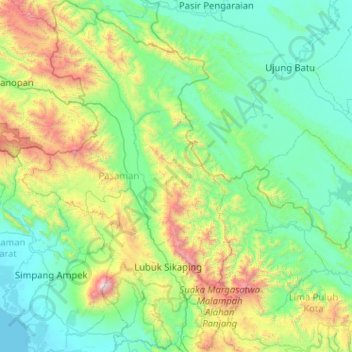
Name: Pasaman topographic map, elevation, terrain.
Location: Pasaman, Sumbar, Indonésie (-0.11435 99.80078 0.90739 100.75533)
Average elevation: 523 m
Minimum elevation: -1 m
Maximum elevation: 2,880 m
Other topographic maps
Click on a map to view its topography, its elevation and its terrain.
Marapi
Indonésie > Sumbar > Bukittinggi
Marapi, Bukittinggi, Agam, Sumbar, Indonésie
Average elevation: 2,609 m