
Thank you for supporting this site ❤️
Make a donation
Make a donation
Almeirim topographic map
Click on the map to display elevation.
Thank you for supporting this site ❤️
Make a donation
Make a donation
About this map
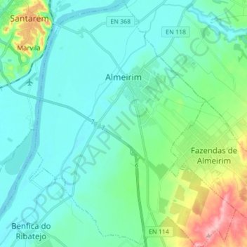
Name: Almeirim topographic map, elevation, terrain.
Location: Almeirim, Santarém, Portugal (39.13700 -8.68694 39.24398 -8.57136)
Average elevation: 33 m
Minimum elevation: 1 m
Maximum elevation: 167 m
Thank you for supporting this site ❤️
Make a donation
Make a donation
Other topographic maps
Click on a map to view its topography, its elevation and its terrain.
Paio Mendes
Portugal > Santarém > Nossa Senhora do Pranto > Frazoeira > Paio Mendes
Average elevation: 298 m
Thank you for supporting this site ❤️
Make a donation
Make a donation