
Thank you for supporting this site ❤️
Make a donation
Make a donation
Klang River topographic map
Click on the map to display elevation.
Thank you for supporting this site ❤️
Make a donation
Make a donation
About this map
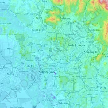
Name: Klang River topographic map, elevation, terrain.
Location: Klang River, Petaling, Selangor, 50050, Malaysia (2.97588 101.37514 3.26109 101.78384)
Average elevation: 72 m
Minimum elevation: -30 m
Maximum elevation: 1,012 m
Thank you for supporting this site ❤️
Make a donation
Make a donation
Other topographic maps
Click on a map to view its topography, its elevation and its terrain.
Kampung Baru Batu Caves
Malaysia > Selangor > Selayang Municipal Council > Batu Caves
Average elevation: 68 m
Thank you for supporting this site ❤️
Make a donation
Make a donation
Kampung Indah Permai
Malaysia > Selangor > Ampang Jaya Municipal Council > Kampung Indah Permai
Average elevation: 137 m
Hulu Kelang
Malaysia > Selangor > Ampang Jaya Municipal Council > Hulu Kelang
Average elevation: 147 m
Thank you for supporting this site ❤️
Make a donation
Make a donation