
Thank you for supporting this site ❤️
Make a donation
Make a donation
Roxton Pond topographic map
Click on the map to display elevation.
Thank you for supporting this site ❤️
Make a donation
Make a donation
About this map
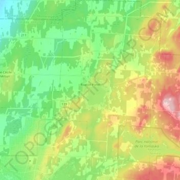
Name: Roxton Pond topographic map, elevation, terrain.
Location: Roxton Pond, La Haute-Yamaska, Quebec, J0E 1Z0, Canada (45.40315 -72.70207 45.53874 -72.57859)
Average elevation: 131 m
Minimum elevation: 50 m
Maximum elevation: 268 m
Thank you for supporting this site ❤️
Make a donation
Make a donation
Other topographic maps
Click on a map to view its topography, its elevation and its terrain.