
Make a donation
Brossard topographic map
Click on the map to display elevation.
Make a donation
About this map
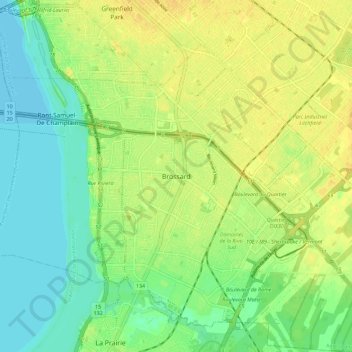
Name: Brossard topographic map, elevation, terrain.
Average elevation: 17 m
Minimum elevation: 5 m
Maximum elevation: 28 m
Make a donation
Other topographic maps
Click on a map to view its topography, its elevation and its terrain.
Make a donation
Greenfield Park
Canada > Quebec > Urban agglomeration of Longueuil > Longueuil
Average elevation: 21 m
Réserve naturelle du Boisé-Du Tremblay
Canada > Quebec > Urban agglomeration of Longueuil > Longueuil
Average elevation: 30 m
Parc Michel Chartrand
Canada > Quebec > Urban agglomeration of Longueuil > Longueuil
Average elevation: 28 m
Make a donation
Îles de Boucherville
Canada > Quebec > Urban agglomeration of Longueuil > Boucherville
Average elevation: 15 m
Parc national des Îles-de-Boucherville
Canada > Quebec > Urban agglomeration of Longueuil > Boucherville
Average elevation: 11 m
Mont-Saint-Bruno National Park
Canada > Quebec > Urban agglomeration of Longueuil > Saint-Bruno-de-Montarville
Mount Saint-Bruno is an inselberg that reaches 218 metres (715 ft) in altitude, above a plain with an average altitude of 30 metres (98 ft). Its highest summits are situated on its north-eastern flank and form an ellipse around the "lac des Bouleaux" (Birch Lake). Its outer terrain gradually recedes towards…
Average elevation: 55 m
Make a donation
Make a donation