
Thank you for supporting this site ❤️
Make a donation
Make a donation
Rocklands Bay topographic map
Click on the map to display elevation.
Thank you for supporting this site ❤️
Make a donation
Make a donation
About this map
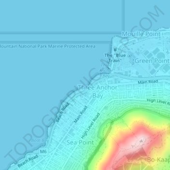
Name: Rocklands Bay topographic map, elevation, terrain.
Location: Rocklands Bay, Cape Town, Western Cape, 8060, South Africa (-33.90820 18.39313 -33.90810 18.39323)
Average elevation: 39 m
Minimum elevation: 0 m
Maximum elevation: 351 m
Thank you for supporting this site ❤️
Make a donation
Make a donation
Other topographic maps
Click on a map to view its topography, its elevation and its terrain.