
Thank you for supporting this site ❤️
Make a donation
Make a donation
Ancash topographic map
Click on the map to display elevation.
Thank you for supporting this site ❤️
Make a donation
Make a donation
Ancash
The park territory is very uneven. It has snowy summits, which altitudes vary between 5000 and 6768 MSL. It also has gullies, that are deeply encased because of the fluvioglacial erosion, and a great number of lagoons. Inside the borders of the park, there are 663 glaciers that are distributed throughout 180 km, from the Tuku in the south up to the Champara in the north.
Thank you for supporting this site ❤️
Make a donation
Make a donation
About this map
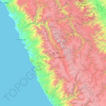
Name: Ancash topographic map, elevation, terrain.
Location: Ancash, Peru (-10.78731 -78.65848 -8.04971 -76.72574)
Average elevation: 2,121 m
Minimum elevation: 0 m
Maximum elevation: 6,632 m
Thank you for supporting this site ❤️
Make a donation
Make a donation
Other topographic maps
Click on a map to view its topography, its elevation and its terrain.
Thank you for supporting this site ❤️
Make a donation
Make a donation
Thank you for supporting this site ❤️
Make a donation
Make a donation