
Thank you for supporting this site ❤️
Make a donation
Make a donation
Bighorn Falls topographic map
Click on the map to display elevation.
Thank you for supporting this site ❤️
Make a donation
Make a donation
About this map
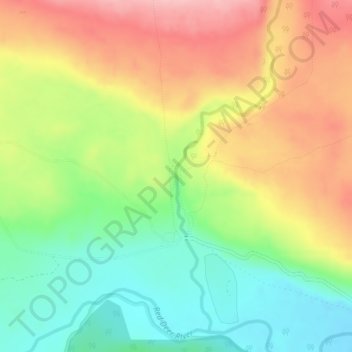
Name: Bighorn Falls topographic map, elevation, terrain.
Location: Bighorn Falls, Clearwater County, Alberta, Canada (51.74059 -115.54175 51.74069 -115.54165)
Average elevation: 1,617 m
Minimum elevation: 1,547 m
Maximum elevation: 1,695 m
Thank you for supporting this site ❤️
Make a donation
Make a donation
Other topographic maps
Click on a map to view its topography, its elevation and its terrain.
Thank you for supporting this site ❤️
Make a donation
Make a donation
Cutoff Creek Equestrian Staging Public Land Recreation Area
Canada > Alberta > Clearwater County
Average elevation: 1,509 m
Thank you for supporting this site ❤️
Make a donation
Make a donation
Hummingbird Public Land Recreation Area
Canada > Alberta > Clearwater County
Average elevation: 1,830 m
Thank you for supporting this site ❤️
Make a donation
Make a donation