
Château de Hagueneck topographic map
Interactive map
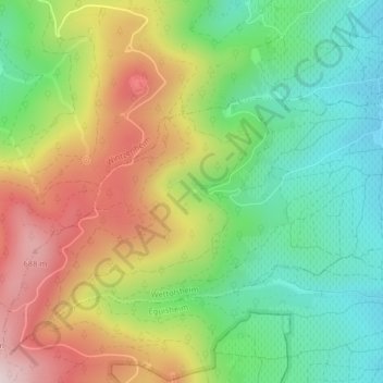
Click on the map to display elevation.
About this map
Name: Château de Hagueneck topographic map, elevation, terrain.
Average elevation: 431 m
Minimum elevation: 231 m
Maximum elevation: 711 m
Le Châtelet du Hagueneck, château de Hagueneck a été édifié vers la fin du XI siècle sur un éperon rocheux à 420 mètres d'altitude dans un vallon au-dessus du village.
Other topographic maps
Click on a map to view its topography, its elevation and its terrain.
Brunnweg
France > Grand Est > Haut-Rhin > Wettolsheim
Brunnweg, Wettolsheim, Colmar-Ribeauvillé, Haut-Rhin, Grand Est, France métropolitaine, 68920, France
Average elevation: 282 m