
Make a donation
Tasikmalaya topographic map
Click on the map to display elevation.
Make a donation
Tasikmalaya
The land of the regency is predominantly hilly, especially in the southern area of the regency. Some are mountainous, as appeared in the northwestern part where Galunggung highlands reside. It is only 13.05% of the region of where its low-lying areas are elevated from zero to 200 metres. The average elevation is 200 to 500 metres. The rest is elevated into the highest point of Mount Galunggung 2,168 metres.
Make a donation
About this map
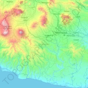
Name: Tasikmalaya topographic map, elevation, terrain.
Location: Tasikmalaya, West Java, Java, Indonesia (-7.81718 107.90449 -7.03720 108.44257)
Average elevation: 560 m
Minimum elevation: 0 m
Maximum elevation: 2,759 m
Make a donation
Other topographic maps
Click on a map to view its topography, its elevation and its terrain.
Bandung
Bandung (Sundanese: ᮘᮔ᮪ᮓᮥᮀ, romanized: Bandung, Sundanese pronunciation: [ˈbandʊŋ]; /ˈbɑːndʊŋ/) is the capital city of the Indonesian province of West Java. It has a population of 2,452,943 within its city limits according to the official estimates as at mid 2021, making it the fourth most…
Average elevation: 879 m
Dusun Cilangkap, Desa Cisempur, Kec. Cibalong, Kab. Tasikmalaya
Indonesia > West Java > Tasikmalaya > Cisempur
Average elevation: 198 m
Make a donation
Make a donation
Make a donation
Make a donation
Dusun Gunung Medang, Desa Kawitan, Kec. Salopa, Kab. Tasikmalaya
Indonesia > West Java > Tasikmalaya
Average elevation: 498 m
Make a donation
Make a donation
Make a donation
Make a donation
Make a donation
Make a donation
Make a donation
Make a donation
Make a donation
Make a donation
Make a donation
Make a donation
Make a donation
Make a donation
Make a donation
Make a donation
Make a donation
Make a donation
Make a donation
Make a donation
Make a donation