
Ashanti Region topographic map
Interactive map
Click on the map to display elevation.
About this map
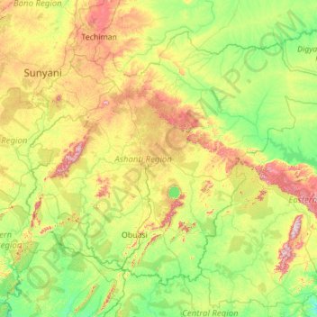
Name: Ashanti Region topographic map, elevation, terrain.
Location: Ashanti Region, Ghana (5.85482 -2.45159 7.62270 -0.23761)
Average elevation: 208 m
Minimum elevation: 33 m
Maximum elevation: 819 m
Other topographic maps
Click on a map to view its topography, its elevation and its terrain.
Accra
Ghana > Greater Accra Region > Korle-Klottey Municipal District
Accra, Korle-Klottey Municipal District, Greater Accra Region, Ghana
Average elevation: 31 m
Atua
Ghana > Western North Region > Aowin Municipal District > Enchi
Atua, Zongo, Enchi, Aowin Municipal District, Western North Region, Ghana
Average elevation: 88 m
Kasoa
Ghana > Central Region > Gomoa East District
Kasoa, Gomoa East District, Central Region, Ghana
Average elevation: 31 m
Dzorwulu
Ghana > Greater Accra Region > Ayawaso West Municipal District > Accra > Dzorwulu
Dzorwulu, Accra, Ayawaso West Municipal District, Greater Accra Region, GA-254-4987, Ghana
Average elevation: 46 m
Elmina
Ghana > Central Region > Komenda/Edina/Eguafo/Abirem Municipal District > Elmina
Elmina, Komenda/Edina/Eguafo/Abirem Municipal District, Central Region, Ghana
Average elevation: 6 m
Tamale
Ghana > Northern Region > Tamale
Tamale, Northern Region, P.O. BOX 232, Ghana
Average elevation: 151 m