
Thank you for supporting this site ❤️
Make a donation
Make a donation
Niedermuhlern topographic map
Click on the map to display elevation.
Thank you for supporting this site ❤️
Make a donation
Make a donation
About this map
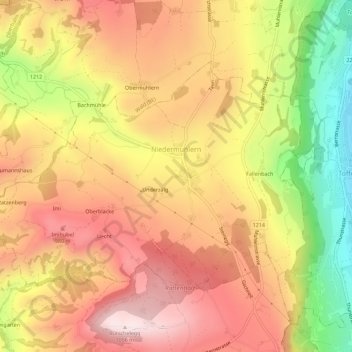
Name: Niedermuhlern topographic map, elevation, terrain.
Average elevation: 834 m
Minimum elevation: 527 m
Maximum elevation: 1,050 m
Thank you for supporting this site ❤️
Make a donation
Make a donation
Other topographic maps
Click on a map to view its topography, its elevation and its terrain.
Gurten
Suisse > Berne > Arrondissement administratif de Berne-Mittelland > Köniz
Average elevation: 677 m
Zimmerwald
Suisse > Berne > Arrondissement administratif de Berne-Mittelland > Wald (BE)
Average elevation: 775 m
Herrenschwanden
Suisse > Berne > Arrondissement administratif de Berne-Mittelland
Average elevation: 560 m
Berne
Suisse > Berne > Arrondissement administratif de Berne-Mittelland > Berne
Average elevation: 643 m
Thank you for supporting this site ❤️
Make a donation
Make a donation
Schloss Wittigkofen
Suisse > Berne > Arrondissement administratif de Berne-Mittelland > Berne > Schloss Wittigkofen
Average elevation: 568 m