
Michoacán topographic map
Interactive map
Click on the map to display elevation.
About this map
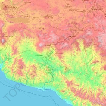
Name: Michoacán topographic map, elevation, terrain.
Location: Michoacán, Mexico (17.91491 -103.73905 20.39452 -100.06303)
Average elevation: 1,239 m
Minimum elevation: 0 m
Maximum elevation: 3,919 m
Much of the climate of the state is determined by altitude and other geographical features. Average temperatures vary from 13 °C (55 °F) to 29 °C (84 °F). Lower temperatures correspond with the highland areas in the north and east while the lower south and west, called La Costa (the coast) or Tierra Caliente (hot land) register higher temperatures. In the hotter lowlands, high temperatures regularly exceed 30 °C (86 °F) and have been known to reach over 40 °C (104 °F) in the summer. The lowest temperatures are registered in highland areas such as the Sierra de Coalcomán and the Sierra del Centro located near the border with the State of Mexico. Except for the Tierra Caliente, most of the state can experience freezing temperatures in the winter. Rainfall is also dependent on altitude with the lowlands receiving less rain than the mountain areas. There is a well-defined rainy season which extends from June to October over the entire state.
Other topographic maps
Click on a map to view its topography, its elevation and its terrain.
San José el Verde
San José el Verde, El Salto, Región Centro, Jalisco, 45694, Mexico
Average elevation: 1,551 m
San Felipe
Mexico > Baja California > Municipio de San Felipe
San Felipe, Municipio de San Felipe, Baja California, 21079, Mexico
Average elevation: 34 m
La Casa de Piedra
Mexico > Sonora > Villa Hidalgo
La Casa de Piedra, Villa Hidalgo, Sonora, Mexico
Average elevation: 726 m
Acapulco
Mexico > Guerrero > Acapulco de Juárez
Acapulco, Acapulco de Juárez, Guerrero, 39300, Mexico
Average elevation: 99 m
San Quintín
Mexico > Baja California > Municipio de San Quintín
San Quintín, Municipio de San Quintín, Baja California, 22932, Mexico
Average elevation: 36 m
Tepetiltic
Mexico > Nayarit > San Pedro Lagunillas
Tepetiltic, San Pedro Lagunillas, Nayarit, Mexico
Average elevation: 1,520 m
Naucalpan de Juárez
Naucalpan de Juárez, State of Mexico, Mexico
Average elevation: 2,366 m
Nezahualcóyotl
Nezahualcóyotl, State of Mexico, Mexico
Average elevation: 2,235 m
Malibu
Mexico > Chiapas > Tuxtla Gutiérrez > Terán
Malibu, Terán, Tuxtla Gutiérrez, Chiapas, 29025, Mexico
Average elevation: 645 m
Santa Rosa Jauregui
Mexico > Querétaro > Municipio de Querétaro
Santa Rosa Jauregui, Municipio de Querétaro, Querétaro, Mexico
Average elevation: 1,979 m
Villa del Río
Mexico > Veracruz > Manlio Fabio Altamirano
Villa del Río, Manlio Fabio Altamirano, Veracruz, Mexico
Average elevation: 45 m
Santa Maria
Mexico > Chihuahua > Namiquipa > El Terrero
Santa Maria, El Terrero, Namiquipa, Chihuahua, Mexico
Average elevation: 1,936 m
Durango
Mexico > Durango > Municipio de Durango > Durango
Durango, Municipio de Durango, Durango, Mexico
Average elevation: 1,936 m
Lázaro Cárdenas
Mexico > Michoacán > Lázaro Cárdenas > Lázaro Cárdenas
Lázaro Cárdenas, Michoacán, 60950, Mexico
Average elevation: 42 m
Matamoros
Mexico > Tamaulipas > Matamoros
Matamoros, Municipio de Matamoros, Tamaulipas, 87457, Mexico
Average elevation: 9 m
San Juan la Unión
Mexico > Oaxaca > San Lucas Zoquiápam
San Juan la Unión, San Lucas Zoquiápam, Oaxaca, Mexico
Average elevation: 1,750 m
Ensenada
Mexico > Baja California > Municipio de Ensenada
Ensenada, Municipio de Ensenada, Baja California, Mexico
Average elevation: 184 m
Rincón de Romos
Mexico > Aguascalientes > Rincón de Romos
Rincón de Romos, Aguascalientes, 20603, Mexico
Average elevation: 1,981 m
Ecatepec de Morelos
Ecatepec de Morelos, State of Mexico, Mexico
Average elevation: 2,288 m
Cabo San Lucas
Mexico > South Lower California > Cabo San Lucas
Cabo San Lucas, Los Cabos, South Lower California, 23470, Mexico
Average elevation: 94 m
Puerto Vallarta
Mexico > Jalisco > Puerto Vallarta
Puerto Vallarta, Jalisco, 48300, Mexico
Average elevation: 306 m