
Make a donation
Netherlands topographic map
Click on the map to display elevation.
Make a donation
Netherlands
The Netherlands is renowned for its exceptionally flat terrain, with approximately 26% of its land lying below sea level. This low-lying landscape is characterized by extensive polders—tracts of land reclaimed from the sea and protected by an intricate system of dikes and canals. The western coastline is lined with sand dunes that serve as natural barriers against the North Sea. In contrast, the southeastern region near the town of Vaals features the Vaalserberg, the country's highest point at 322.7 meters (1,059 feet) above sea level. Overall, the Dutch landscape is predominantly flat, interspersed with these modest elevations and shaped significantly by human intervention to manage and reclaim land from water.
Make a donation
About this map
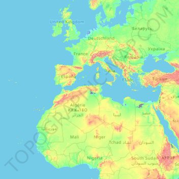
Name: Netherlands topographic map, elevation, terrain.
Location: Netherlands (11.82500 -68.62553 53.74440 7.22750)
Average elevation: 251 m
Minimum elevation: -72 m
Maximum elevation: 5,016 m
Make a donation
Other topographic maps
Click on a map to view its topography, its elevation and its terrain.
Make a donation
Africa
Africa's topography is a complex tapestry of plateaus, mountains, valleys, and deserts. The continent is dominated by vast plateaus, with elevations averaging around 1,000 meters (3,281 feet), especially prominent in the south and east. The Ethiopian Highlands, often referred to as the "Roof of Africa," rise…
Average elevation: 462 m
Make a donation
Fort Canning Park
The hill has a long history intertwined with that of the country due to its location as the highest elevation within walking distance to the city's civic district, within the Downtown Core. It is also a popular location for exhibitions, concerts, and outdoor recreation.
Average elevation: 19 m
Make a donation
Make a donation
Make a donation
Make a donation
Make a donation
Make a donation
San Jose
The municipality is in a valley bounded on the east by the Palusong Mountain Range moving south and on the west by the Hitaasan Mountain Range. The land is generally alluvial flat and swamplands which has an elevation of less than 10 metres (33 ft) above sea level, while going south, south easterly, the…
Average elevation: 15 m
Make a donation
Make a donation
Kampos Marathokampou
Greece > Northern Aegean > Samos Regional Unit > Municipal Unit of Marathokabos
Average elevation: 99 m
Make a donation
Make a donation
Addis Ababa
Ethiopia > Addis Ababa > Arada
Addis Ababa (/ˌædɪs ˈæbəbə/ AD-iss AB-ə-bə; Amharic: አዲስ አበባ [adˈdis ˈaβəβa] , lit. 'new flower'; Oromo: Finfinnee, lit. 'fountain of hot mineral water') is the capital city of Ethiopia. With an estimated population of 2,739,551 inhabitants as of the 2007 census, it is the largest…
Average elevation: 2,517 m
Bsharri
Bsharri (Arabic: بشرّي Bšarrī; also romanized Becharre, Bcharre, Bsharre, Bcharre Al Arz) is a Lebanese town located in the district of the same name, North Governorate, situated at altitudes between 1,100 m (3,600 ft) and 3,088 m (10,131 ft). Bsharri is the location of the Cedars of God, a UNESCO World…
Average elevation: 1,847 m
Make a donation
Kotdwar
India > Uttarakhand > Kotdwara
Kotdwar lies on the western margin of the Himalayas, at an altitude of 454 m (1,490 ft) above sea level.
Average elevation: 641 m
Make a donation
Sinabad
Iran > West Azerbaijan Province > Urumia County > دهستان صومای جنوبی
Average elevation: 1,876 m
Make a donation
Make a donation
Aramoun
Lebanon > Mount Lebanon Governorate
Aramoun (Arabic: عرمون) is a village in the Aley District of Mount Lebanon, Lebanon, lying to the east of Khalde and 22 kilometres away from Beirut. Aramoun's altitude ranges between 250 meters to 600 meters further east. The village has a Druze and Christian community, major families are Yehia, Jawhari,…
Average elevation: 467 m
Corró d'Amunt
Spain > Catalonia > Vallès Oriental > les Franqueses del Vallès
Average elevation: 287 m
Make a donation
Pièce du Moulin
France > Nouvelle-Aquitaine > Charente-Maritime > Le Grand-Village-Plage
Average elevation: 4 m
Make a donation
Make a donation
Make a donation
Make a donation
Make a donation
Make a donation
Αβία
Greece > Peloponnese Region > Messenia Regional Unit > Municipal Unit of Avia
Average elevation: 45 m
Make a donation
Make a donation