
Thank you for supporting this site ❤️
Make a donation
Make a donation
Monte Rinaldo topographic map
Click on the map to display elevation.
Thank you for supporting this site ❤️
Make a donation
Make a donation
About this map
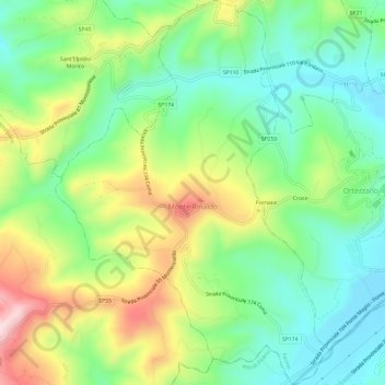
Name: Monte Rinaldo topographic map, elevation, terrain.
Location: Monte Rinaldo, Fermo, Marche, 63852, Italy (43.00819 13.55898 43.05145 13.60120)
Average elevation: 321 m
Minimum elevation: 192 m
Maximum elevation: 546 m
Thank you for supporting this site ❤️
Make a donation
Make a donation
Other topographic maps
Click on a map to view its topography, its elevation and its terrain.