
Seongnam topographic map
Interactive map
Click on the map to display elevation.
About this map
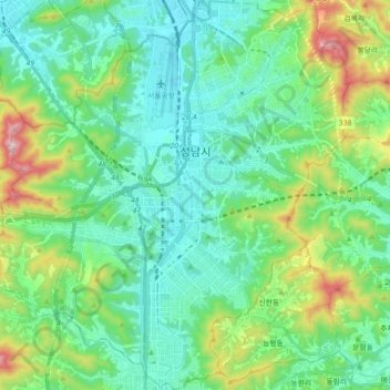
Name: Seongnam topographic map, elevation, terrain.
Location: Seongnam, Gyeonggi, Corée du Sud (37.33339 127.02707 37.47481 127.19596)
Average elevation: 150 m
Minimum elevation: 9 m
Maximum elevation: 601 m
Other topographic maps
Click on a map to view its topography, its elevation and its terrain.