
Aguasantas topographic map
Interactive map
Click on the map to display elevation.
About this map
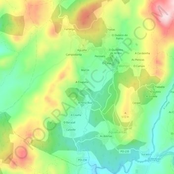
Name: Aguasantas topographic map, elevation, terrain.
Location: Aguasantas, Cerdedo-Cotobade, Pontevedra, Galicië, Spanje (42.41086 -8.49317 42.45312 -8.43550)
Average elevation: 487 m
Minimum elevation: 347 m
Maximum elevation: 693 m
Other topographic maps
Click on a map to view its topography, its elevation and its terrain.
O Trebello
Spanje > Galicië > Pontevedra
O Trebello, Aguasantas, Cerdedo-Cotobade, Pontevedra, Galicië, 36838, Spanje
Average elevation: 502 m