
Ampang Jaya Municipal Council topographic map
Interactive map
Click on the map to display elevation.
About this map
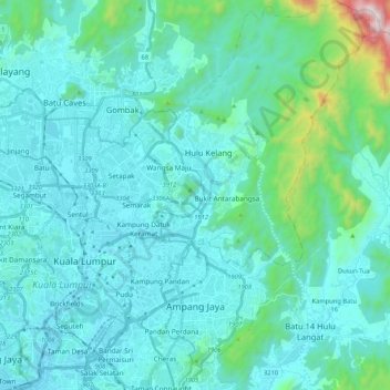
Name: Ampang Jaya Municipal Council topographic map, elevation, terrain.
Location: Ampang Jaya Municipal Council, Hulu Langat, Selangor, Malaysia (3.08231 101.73105 3.29186 101.85369)
Average elevation: 167 m
Minimum elevation: 18 m
Maximum elevation: 1,286 m
Other topographic maps
Click on a map to view its topography, its elevation and its terrain.
Sungai Kerayong
Malaysia > Selangor > Ampang Jaya Municipal Council
Sungai Kerayong, Ampang Jaya Municipal Council, Hulu Langat, Selangor, 51500, Malaysia
Average elevation: 67 m
Hulu Kelang
Malaysia > Selangor > Ampang Jaya Municipal Council > Hulu Kelang
Hulu Kelang, Ampang Jaya Municipal Council, Gombak, Selangor, 53100, Malaysia
Average elevation: 147 m
Kampung Indah Permai
Malaysia > Selangor > Ampang Jaya Municipal Council > Kampung Indah Permai
Kampung Indah Permai, Ampang Jaya Municipal Council, Hulu Langat, Selangor, 68000, Malaysia
Average elevation: 137 m