
Thank you for supporting this site ❤️
Make a donation
Make a donation
Crocodile topographic map
Click on the map to display elevation.
Thank you for supporting this site ❤️
Make a donation
Make a donation
About this map
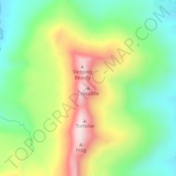
Name: Crocodile topographic map, elevation, terrain.
Average elevation: 1,640 m
Minimum elevation: 1,409 m
Maximum elevation: 1,979 m
Thank you for supporting this site ❤️
Make a donation
Make a donation
Other topographic maps
Click on a map to view its topography, its elevation and its terrain.
Woodstock Dam
South Africa > KwaZulu-Natal > Uthukela District Municipality > Okhahlamba Local Municipality
Average elevation: 1,192 m
Okhahlamba Ward 6
South Africa > KwaZulu-Natal > Uthukela District Municipality > Okhahlamba Local Municipality
Average elevation: 1,903 m
Spioenkop Dam
South Africa > KwaZulu-Natal > Uthukela District Municipality > Okhahlamba Local Municipality
Average elevation: 1,139 m
Spioenkop Dam
South Africa > KwaZulu-Natal > Uthukela District Municipality > Okhahlamba Local Municipality
Average elevation: 1,139 m
Thank you for supporting this site ❤️
Make a donation
Make a donation