
Make a donation
Chitwan topographic map
Click on the map to display elevation.
Make a donation
About this map
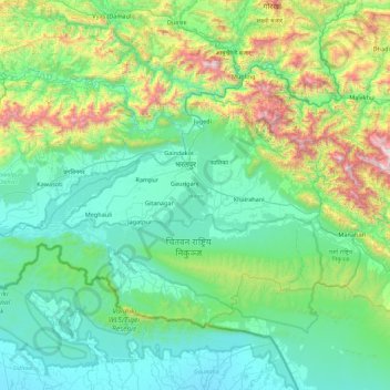
Name: Chitwan topographic map, elevation, terrain.
Location: Chitwan, Bagmati Pradesh, Nepal (27.35613 83.91936 27.88088 84.79637)
Average elevation: 469 m
Minimum elevation: 93 m
Maximum elevation: 2,084 m
Make a donation
Other topographic maps
Click on a map to view its topography, its elevation and its terrain.
Make a donation
Khumjung
Nepal > Koshi Province > Solukhumbu
Khumjung (Nepali: खुम्जुंग) is a village in Khumbu Pasanglhamu rural municipality of Solukhumbu District in Province No. 1 of north-eastern Nepal. It is located in the Khumbu subregion inside Sagarmatha National Park, a world heritage site. The village is at an elevation of 3,790 metres above…
Average elevation: 3,888 m
Western Development Region
The Western Development Region (Nepali: पश्चिमाञ्चल विकास क्षेत्र, Pashchimānchal Bikās Kshetra) was one of Nepal's five development regions. It was located in the west-central part of the country, with its headquarters located in Pokhara. This Development Region…
Average elevation: 2,742 m
Make a donation
Mount Everest
Nepal > Koshi Province > Solukhumbu
Mount Everest (Nepali: सगरमाथा, romanized: Sagarmāthā; Tibetan: Chomolungma ཇོ་མོ་གླང་མ; Chinese: 珠穆朗玛峰; pinyin: Zhūmùlǎngmǎ Fēng) is Earth's highest mountain above sea level, located in the Mahalangur Himal sub-range of the Himalayas. The China–Nepal…
Average elevation: 7,850 m