
Thank you for supporting this site ❤️
Make a donation
Make a donation
Stalker Island topographic map
Click on the map to display elevation.
Thank you for supporting this site ❤️
Make a donation
Make a donation
About this map
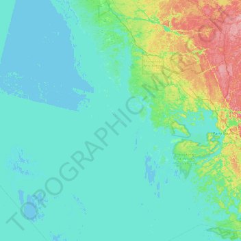
Name: Stalker Island topographic map, elevation, terrain.
Average elevation: 188 m
Minimum elevation: 172 m
Maximum elevation: 281 m
Thank you for supporting this site ❤️
Make a donation
Make a donation
Other topographic maps
Click on a map to view its topography, its elevation and its terrain.
Killbear Provincial Park
Canada > Ontario > Parry Sound District > Carling Township
Average elevation: 184 m