
Make a donation
Potchefstroom topographic map
Click on the map to display elevation.
Make a donation
Potchefstroom
Potchefstroom has hosted two World Cup-winning teams (in cricket and football) and serves as a home away from home for many international athletes and teams. At an altitude of 1,400 metres (4,600 ft), it offers a good balance between elevation and quality training conditions. The city's good air quality, due to the absence of large factories, is also beneficial for training. Athletes and professional teams often train at the North-West University's High Performance Institute of Sport.
Make a donation
About this map
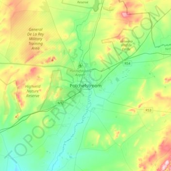
Name: Potchefstroom topographic map, elevation, terrain.
Average elevation: 1,393 m
Minimum elevation: 1,299 m
Maximum elevation: 1,614 m
Make a donation
Other topographic maps
Click on a map to view its topography, its elevation and its terrain.
Matlosana Local Municipality
South Africa > North West > Dr Kenneth Kaunda District Municipality
Average elevation: 1,414 m
Matlosana Local Municipality
South Africa > North West > Dr Kenneth Kaunda District Municipality
Average elevation: 1,414 m
Tlokwe Local Municipality
South Africa > North West > Dr Kenneth Kaunda District Municipality
Average elevation: 1,427 m
Maquassi Hills Local Municipality
South Africa > North West > Dr Kenneth Kaunda District Municipality
Average elevation: 1,335 m
Make a donation
Maquassi Hills Local Municipality
South Africa > North West > Dr Kenneth Kaunda District Municipality
Average elevation: 1,335 m
Boskop Dam
South Africa > North West > Dr Kenneth Kaunda District Municipality > Tlokwe Local Municipality > Boskop
Average elevation: 1,399 m