
Make a donation
Portimão topographic map
Click on the map to display elevation.
Make a donation
Portimão
The geographical distribution of the altitude and relief of the municipality of Portimão generically follow the three types of territory present in the Barlavento: the coastal region, the Barrocal (a region between the coastal region and the mountains) and the mountains up north. Each one with their own geological, morphological and pedagogical characteristics.
Make a donation
About this map
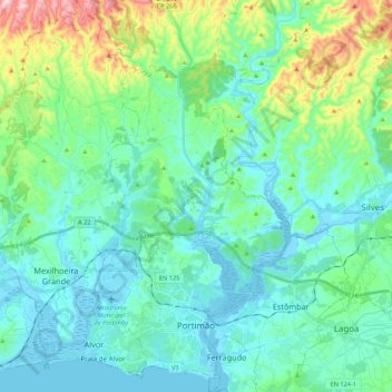
Name: Portimão topographic map, elevation, terrain.
Location: Portimão, Faro, Portugal (37.10842 -8.68466 37.27992 -8.48520)
Average elevation: 67 m
Minimum elevation: -8 m
Maximum elevation: 332 m
Make a donation
Other topographic maps
Click on a map to view its topography, its elevation and its terrain.
Make a donation
Algarve
The Algarve is located in the southernmost area of continental Portugal and the southwesternmost area of the Iberian Peninsula and mainland Europe, covering an area of 4,997 km2 (1,929 sq mi). It borders to the north with the Alentejo region (Alentejo Litoral and Baixo Alentejo), to the south and west with the…
Average elevation: 72 m
Make a donation
Make a donation
Make a donation
Make a donation
Make a donation
Make a donation
Make a donation
São Brás de Alportel
Portugal > Faro > São Brás de Alportel > São Brás de Alportel
Average elevation: 254 m
Make a donation
Make a donation
Make a donation
Juncais
Portugal > Faro > São Brás de Alportel > São Brás de Alportel > Juncais
Average elevation: 310 m
Belo Romão
Portugal > Faro > Moncarapacho e Fuseta > Moncarapacho > Belo Romão
Average elevation: 27 m
Make a donation